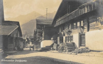
Start of the Zwergliloch Trail
The circular trail to Zwergliloch is a varied hike around Brienzwiler. Duration is approximately 1 hour.
NOT SUITABLE FOR PEOPLE WITH MOBILITY IMPAIRMENTS AND SMALL CHILDREN

By Stagecoach over the Brünig
The Brünig Pass road has likely existed since the early Middle Ages. At that time, Brienzwiler was still known as “Wyler am Brünig.” The trade relationship between Central Switzerland and the Bernese Oberland is mentioned. Goods were initially transported by packhorses and later by stagecoach from Alpnach to Brienz, and from there by boat to Interlaken.
Until the 19th century, the main thoroughfare, which came from Brienz and Hofstetten via “Schloss,” ran right through the village. Before the road ascended again towards the Brünig, horses for the carriages were changed in the Aenderdorf.
Consequently, until the construction of the newer Brünig road, the post office was also located here. Some buildings that are still preserved today served at that time as stables, inns, or hotels.
Pilgrims and Travelers – The Development of Tourism
In the Middle Ages (at least until the Reformation), pilgrims also crossed the Brünig. Even today, the pilgrim hostel in Brienzwiler is used as a stopover on the Camino de Santiago. One can only imagine how greatly a simple accommodation was appreciated after a strenuous passage over the pass in earlier times.
Historically, there has always been a lively exchange of goods between Central Switzerland, the Bernese Oberland, and the southern side of the Alps. A variety of trade goods were transported north and south. In the old Confederation, a few assemblies took place in Kienholz (Brienz), facilitating a certain political exchange between Central Switzerland and Bern on this route. Allegedly, the legendary Brother Klaus, who served the then Canton of Obwalden, also passed through Brienzwiler.
In the 19th century, tourism in the Bernese Oberland gained increasing importance. As traveling was still arduous at that time, it can be assumed that the inns in Brienzwiler were often used as accommodation before crossing the pass. The Brünig road, especially the prominent rock at Balmi, became a popular motif for postcards and travel reports. So the famous American author Mark Twain described the journey over the Brünig in a horse-drawn carriage in his work “A Tramp Abroad” from 1880 with the following words:
Source: Wikisource
With the inauguration of the Brünig Railway on June 13, 1888, the era of the stagecoach came to an end. Most goods and tourists were then transported by rail. Today, the well-developed road is mainly used for private and commercial traffic and serves as the most important connection between the Oberland and Central Switzerland.


Transport Axis over the Brünig Pass & Tourism
The original road that led from Hofstetten through the castle to Brienzwiler is already mentioned in the oldest records. At some point in the course of the 19th century, the main traffic route no longer passed through the narrow streets of the Aenderdorf. The Brünigstrasse, which bypasses the village center of Brienzwiler, was built in the second half of the 19th century. On July 6, 1995, the bypass tunnel (Soliwald Tunnel) was opened. Since then, the main traffic no longer flows through the village, which has brought significant tranquility to Brienzwiler as a residential area.
Today, Brienzwiler is primarily known for its proximity to the Swiss Open-Air Museum Ballenberg. The original, ornately carved wooden church of Brienzwiler is located directly next to the eastern entrance of the Ballenberg Museum. Here, you can also find the Märithüsli, where popular Jenny shirts and simple catering options are available.
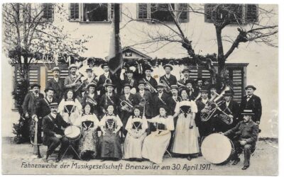
Picture archive (old postcards, photos and illustrations)
Locations of the Virtual Tour
Nature garden
Nature gardenGoethe on the Wyler BridgeIt is October 13, 1779 – three well-dressed gentlemen step onto the Wyler Bridge down in the valley. One of them would later dictate to his secretary at the Hotel Kreuz in Brienz how they marveled at the “terrifying mountain...
Griid
GriidOltschiburgSecret flight exercise behind the Oltschiburg with the Fieseler StorchOn November 19, 1946, an American Douglas C-53 (Dakota) crashed in rugged terrain at 3350 m above sea level on the Gauli Glacier. All occupants survived the crash landing in the...
Fresco Schoolhouse
Fresco SchoolhouseFresco Schoolhouse/Allmendnussen"God gave us the nuts; let us crack them together!"This saying accompanies the sgraffito at the Brienzwiler schoolhouse. It was created by Heinz Schild and his team to commemorate the construction of the new gymnasium....
Church
ChurchChurchThe small, cozy wooden church with 160 seats was built with contributions from the canton and the Synod Council, as well as countless volunteer hours from the local community, and was consecrated in 1940.The building materials primarily come from the...
Village square
Village squareHistory of the Coat of Arms“Wyler am Brünig”, as Brienzwiler was once called, has always been located on the important transit axis of the Brünig Pass. The old path led from Kienholz (Brienz) via Hofstetten to the “Schloss” district of Brienzwiler and...
